Home

Mount Tara
Photo
Offer
Quest book
 
Kaludjerske bare
Mitrovac
Zaovine
Šljivovica
Predov krst
Sokolina
Photo on DeviantART

Mount Tara and drina River

tara sobe, tara apartmani, smestaj


M A P

Offer


 Fotolia

Tara

Vacation

www.tara-planina.com

Tara is located in western Serbia. It is a part of Dinaric Alps and covers an area of 183 km2. Its length is 50 km, and it is 22 km wide, with average height of 1200 m above sea level. Its highest point is Kozji rid - 1591 m.

Tara is a good place for building tourist objects. There are lots of places with great amount of sunshine and little wind. During winter you can engage in beginner or Nordic skiing or sleighing. Opportunities for alpine skiing are limited due to shortness of chutes, which is less than 2 km.

read more...

Pictures gallery

On July the 13. 1981. Tara becomes a National park covering area of 19.175 ha.

Due to its climate and isolation Tara preserved ancient species of trees such as pancic spruce and other almost fossil species of plants. Tara is mostly made of limestone and its average height is 1000-1200m. The highest point is Kozji Rid -1591m and the lowest 291m is at the lake Perućac. Vrelo River is the strongest fountain in the national park, which runs into river Drina after 365 meters. Summers are fresh and winters are cold with lots of snow. Most rainfall is in May. Driest months are July and August. Autumn is sunny and warmer then spring.

NP Tara is 80% covered with forests. There are 34 forest and 19 meadow communities. 75% of forests are mixed spruce-fir, fir and beech. Besides Pančić spruce significant plants are hazel, yew, holly, jeremičak, knapweed of derventa, peony, blechnum spicant

read more...


Kaluđerske bare

Mitrovac

Zaovine

Kaludjerske bare is 16 km from Bajina Bašta. It is in the southeastern part of Tara and its most important tourist center with beautiful woods of black and white pine, fir, spruce fir. Kaludjerske bare are on 1059 m. There are foot-paths, chutes, and sleighing fields.

read more...


Mitrovac is on the twenty fifth km from Bajina Bašta towards Zaovine.

Mitrovac is on 1080 m above the sea level. It has a very good climate with many days with lots of sunshine.


read more...


Zaovine is located in western Serbia at the municipality of Bajina Bašta. Village Zaovine is made of 28 smaller villages on mountainous terrain covered with forest. There is lake   Zaovine and canyon of white Rzav called „Sklopovi“.

It is in the southern part of Tara called the flat Tara. Geologically it is natural connection between Tara and Zlatibor and Mokra Gora valley. Its minimal elevation is 784 m and maximal is 1.412 m (peak Miloševac) It covers area of 5.593,61 ha

read more...

Šljivovica

Sokolina

Predov krst

Šljivovica is on the road Kaluđerske Bare-Mitrovac. Its inhabitid mostly with farmers and people who have weekend houses there. It is 21 km from Bajina Bašta and 5 km from Kaluđerske Bare.


read more...


Sokolina is 8 km from Kaluđerske bare. It has great tourist potential. Plateau with beautiful meadows surrounded by woods of fir, spruce-fir and beech is a real air spa.


read more...


Predov krst is on 1075 m above the sea. You can get there via Bajina Basta and   Perućac, through  the narrow canyon of small river Derventa, via Rastište.

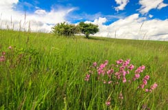
It is located in the farthest westernmost part of Tara. Lake Perucac and some hills make border with Bosnia and Herzegovina. Due to its remoteness, animal and plant life in this area are well preserved. You can find untouched nature there.                                     

read more...

P R O M O


TARA photo......here


Mount Tara - rooms - apartments - informations - pictures gallery

TARA  2007-2020